Rupin Pass Trek is not just a trek; It is a dramatic trip that sounds like going through the pages of an epic novel. Huge waterfalls, hanging villages, snow bridges, cedar forests, ice dollars and an exciting high-height departure give all this and more.
This high mountain spruce is located at a height of 15,250 feet, connecting Dhaula in Uttarakhand to Sangla from Himachal Pradesh, making it one of the most diverse and brave trails in the Indian Himalayas. For severe, in search of an exciting, more terrain adventure, a bucket list is required to be a bucket list.
Why choose Rupin Pass Trek?
Dramatic
From dense oak and rhododendrons -forests to icy grasslands and roar rivers each day brings another scenario on the Rupin trek. The view is not just beautiful – it changes luxuriously with each step.
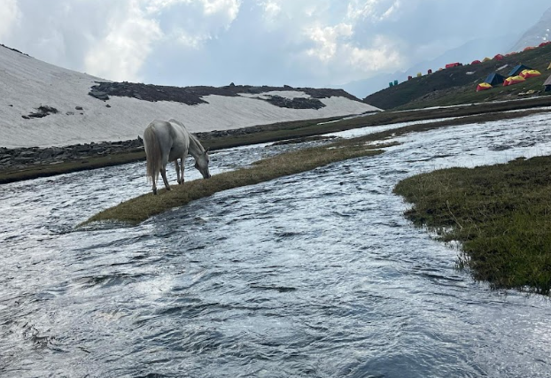
Representative “Rupin Waterfall Campsite”
Camping in front of the famous Rupin Waterfall is a magical experience. The waterfall cascade is done at a height of hundreds of meters, forming natural snow bridges, and the view is no less than the real one.
Adrenalin-pumping passing
The last day entails a challenging climb for Rupin Pass, followed by an exciting descent in the Sangla valley. The snowy paths and panoramic views of Kinnur and the Garhwal series make it the most rewarding part of the trip.
Journey Through Diverse Landscapes and Cultures
The Rupin Pass Trek is not just a trek; it’s a journey that unfolds like a grand Himalayan story. Starting from the charming village of Dhaula in Uttarakhand and culminating in Sangla, Himachal Pradesh, the trail offers a dramatic change in scenery every single day. From dense pine forests and hanging villages to snow bridges and cascading waterfalls, the trek is a visual masterpiece. Trekkers also get a chance to interact with local communities, offering glimpses into the rich culture of the region.
The Thrill of Crossing the High-Altitude Rupin Pass
Standing at over 15,000 feet, the Rupin Pass is the crown jewel of the trek. The final ascent to the pass is steep, challenging, and covered in snow for most of the year—making it a thrilling experience for adventure seekers. As you reach the top, panoramic views of the Kinnaur Kailash range unfold, rewarding your effort with unforgettable sights. This stretch truly tests your endurance and grit, making the Rupin Pass Trek ideal for those looking to push their limits in the Himalayas.
Detailed travel program
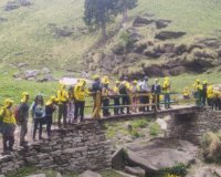
Day 1: Arrival to Dhaula (5,100 FT)
Drive from Dehradun to Dhaula (about 10 hours). Overnight in the tent. The journey is beautiful overlooking the rivers Yamuna and Ton.
Day 2: Dhaula to Swa (6,300 ft)
Wooden spacing: 11 km | Duration: 6–7 hoursCross small villages and dense cedar forests. You will see the wooden bridges hang and now the service village known for your ancient temple.
Day 3: Service from service (8 700 FT)
Wooden spacing: 9 km | Duration: 6–7 hours Trek with the Rupin River via apple gardens and terraced fields. Now Zhaka known as “Hanging Village” because of your steep location.
Day 4: Jhaka to Suruwas Thach (10,200 FT)
Wooden spacing: 6 km | Duration: 5-6 hours
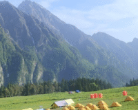
Clear cedar and rhododendrone through forests. The footpath leads you to the juicy grasslands in Suruwas.
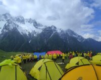
Day 5: Suruwas Thach to Dangaras Thach (11 700 feet)
Wooden spacing: 5 km | Duration: 4-5 hours
Walk into the wide valley with the powerful Rupin -foss in the background. Camp right in front of the waterfall.
Day 6: Acclimatization and Investigation Day
Explore the area and relax. Go for a short growth or acclimate on the right for high passports the following day.
Day 7: Dhandas Thach to Upper Journ Camp (13,300 feet)
Wooden spacing: 3 km | Duration: 3–4 hours
Climb ice bridges next to the waterfall. Step areas and ice can make this part challenging.
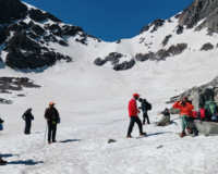
Day 8: Ronti Gad (13,000 feet) from Rupin Pass (15 250 feet) from Upper Foss
Wooden spacing: 10 km | Duration: 10 hours
Start early. The nearby climb is standing and snowy. Now the summit with fascinating ideas. Get carefully for Ronti Gads Gresslett.
Day 9: Ronti Gad to Sangla (8,800 ft)
Trek distance: 12 km | Duration: 6–7 hours
Descend to the village of Sangla, your final destination. From here, drive back to Shimla or continue your Himachal journey.
Best Time to Visit

- Summer (Mid-May to June end): Snowfields, pleasant weather, blooming rhododendrons.
- Autumn (Mid-September to October): Clear skies, golden meadows, and post-monsoon freshness.
Avoid monsoon season due to landslides and winter due to extreme snowfall.
Fitness Requirements
- Cardiovascular endurance (able to jog 4–5 km in 30 minutes)
- Leg and core strength (lunges, squats, step-ups)
- Altitude training (stair climbing, hiking at higher elevations if possible)
Trek Essentials
Clothing:
- 3–4 quick-dry T-shirts
- 2–3 trek pants
- Down jacket + fleece layer
- Thermal inners
- Woolen cap, gloves, neck warmer
Footwear:
- Trekking shoes with good gripExtra pairs of socks
Accessories:
- Sunglasses, sunscreen, lip balm
- Trekking pole, headlamp
- Personal medication kit
Conclusion
The Rupin Pass Trek is more than just a trek—it’s a transformative Himalayan experience. With its ever-changing landscapes, challenging ascents, and unmatched natural beauty, it tests your limits and rewards you with unforgettable memories.
Whether you’re a seasoned trekker or an adventurer seeking your next big challenge, this high-altitude crossover from Uttarakhand to Himachal should be on your radar.
FAQs about Rupin Pass Trek
1. Is Rupin Pass suitable for beginners?
No, Rupin Pass is best suited for experienced trekkers due to its high altitude, long trekking days, and steep climbs.
2. Is a permit required for this trek?
Yes, entry permits are needed as you trek across state borders and forest areas. We take care of all the necessary permissions.
3. Will there be snow on the trek?
Yes, especially if you trek in May-June or late September, you’ll encounter snow near the pass and upper campsites.
4. How cold does it get at night?
Temperatures can dip to -5°C to -10°C at higher campsites. Proper thermal layering is essential.
5. What is the mobile network availability?
Mobile network disappears after Dhaula. Jio or BSNL might work in bits till Sewa, but expect to be off-grid for most of the trek.
6. Can I charge my phone or use power banks?
Carry a fully charged power bank. Charging facilities are unavailable after the base camp.
7. What about altitude sickness?
Proper acclimatization days and hydration reduce the risk. Our guides monitor all trekkers daily.
8. Is it safe for solo female trekkers?
Yes, the trek is safe. Our groups are led by experienced, professional guides and support staff, including female trek leaders if needed.
9. What is the total trek distance?
Approx. 52 km from Dhaula to Sangla, covered over 8–9 days.
10. What happens in case of an emergency?
Our staff carries oxygen and first-aid. In case of serious emergencies, evacuation procedures are initiated immediately.